Forecasters Call for an Intense Year (Image Credits: Unsplash)
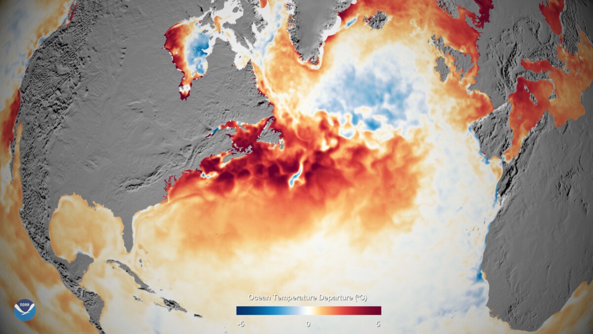
Atlantic waters simmer with unusual warmth this fall, setting the stage for a season that could test communities from the Carolinas to the Caribbean.
Forecasters Call for an Intense Year
Experts at NOAA kicked off predictions back in May, warning of an above-normal hurricane season stretching from June through November. They pointed to neutral ENSO conditions and ocean temperatures running hotter than average as key drivers. This mix often fuels more tropical activity, and so far, the season has delivered with systems like Andrea and Barry making early appearances.
What stands out is how these factors align to boost storm formation. Warmer seas provide the energy, while the lack of strong El Niño or La Niña patterns keeps interference low. Residents along the Gulf Coast have already seen impacts, reminding everyone that preparation isn’t optional.
Still, it’s not all doom. Accurate forecasting tools have improved, giving people more time to respond. Organizations like UNICEF are on standby in Latin America and the Caribbean, ready to support affected areas.
Early Storms Set a Tense Tone
The season didn’t waste time, with Tropical Storm Andrea forming in late June – the latest start since 2014, but quickly followed by Barry hitting Veracruz. Chantal brushed the U.S. East Coast in July, bringing rain and wind without major landfalls. Then August brought Erin, a beast that roared to Category 5 strength near Cape Verde.
Erin’s path spared direct hits but rippled effects to the eastern Caribbean and U.S. Atlantic shores through heavy swells and disrupted shipping. Conditions turned unfavorable after that, slowing new developments, yet the overall count of named storms is climbing toward NOAA’s outlook of 13 to 19.
These early events highlight a pattern: even non-landers can cause trouble. Flooding from outer bands, like what happened with past storms, reaches inland fast.
Recent Twists with Hurricane Melissa
As November approaches, Hurricane Melissa has grabbed headlines, tearing through Jamaica and the Bahamas before eyeing Bermuda. No official death toll in Jamaica yet, but power outages and rough seas have hit hard. The storm is weakening now, expected to pass west of Bermuda as a Category 1 or 2.
Updates from weather trackers show Melissa pulling away, with winds easing over cooler waters. Bermuda faced strong gusts and rain bands, but quick evacuations helped limit damage. Meanwhile, Florida watches closely, as late-season risks linger into December.
This late surge underscores the season’s unpredictability. Forecasters note a dip in activity soon, but anyone in the tropics shouldn’t let guard down.
Broader Impacts Beyond the Coasts
Hurricanes don’t stop at the shoreline. Last year’s Helene and Debby showed how inland flooding can devastate entire regions, far from the ocean. NOAA stresses that these storms amplify risks like power failures and supply chain breaks, hitting vulnerable spots hardest.
In 2025, philanthropy groups track needs across the Atlantic basin, from rebuilding homes to aiding schools. The Wikipedia log already lists eight named storms, with potential for more as we near the end.
Communities are adapting, too. Better early warnings mean fewer surprises, but climate trends suggest these intense seasons might become the norm.
Preparation Tips Every Household Needs
Staying ready boils down to basics that save lives. Stock up on water, non-perishables, and meds for at least three days – think batteries and cash, too, since ATMs fail in outages.
Know your evacuation routes and have a family plan. Apps from the National Hurricane Center deliver real-time alerts, while local offices provide tailored advice. For boat owners or coastal dwellers, securing property early prevents bigger headaches.
- Monitor forecasts daily via NOAA or Weather.com.
- Trim trees and board windows before winds pick up.
- Charge devices and have backup power for essentials.
- Check on neighbors, especially the elderly or alone.
- Review insurance – flood coverage often needs separate policies.
Shifting Patterns and Future Outlook
Looking ahead, 2025’s season wraps officially on November 30, but stragglers like Melissa prove it’s fluid. NOAA’s tools, from satellite data to models, keep improving accuracy, which could cut response times even more.
Yet challenges persist. Warmer oceans from climate change crank up storm power, pushing forecasters to refine long-term views. Groups like the Center for Disaster Philanthropy urge ongoing support for recovery, emphasizing equity in aid.
In the end, knowledge is the best defense. This season reminds us to respect nature’s force while leaning on science to navigate it.
Key Takeaways
- Expect 13-19 named storms, with 6-10 hurricanes and 3-5 majors.
- Focus on inland flooding risks, not just coastal hits.
- Stay informed through official sources for timely action.
One big lesson from 2025: proactive steps today prevent regret tomorrow. How are you prepping for the rest of the season? Share your tips in the comments.