
There’s something oddly humbling about standing in front of a landscape that makes you feel like you’ve just stepped onto another planet. The United States has plenty of those moments waiting for travelers who dare to venture beyond the usual tourist circuits. From ancient sandstone canyons carved by water that barely shows itself to volcanic craters holding lakes so pure they defy logic, these places exist on the edge of believability.
What’s wild is that many of these wonders are still changing, still moving. Nature isn’t finished with them yet. Some are being shaped by forces you can’t even see until it’s too late, while others reveal secrets buried miles beneath the surface. Let’s explore six of them.
The Grand Canyon: A Living Monument to Erosion
The Colorado River continues to reshape the Grand Canyon, a process that won’t stop as long as water flows through it. Geologists estimate that the Grand Canyon is being eroded at a rate of about one foot every 200 years, which sounds slow until you realize it’s been happening for millions of years already.
What catches most people off guard is the sheer scale. You can read about it all you want, but seeing it in person hits differently. The canyon itself formed roughly five million years ago, though the rock layers exposed within it are far older. The colors shift throughout the day as sunlight plays across ancient stone, revealing stripes of geological history that go back hundreds of millions of years.
Standing at the rim feels like looking into time itself. This incredible formation was carved over millions of years by the Colorado River, cutting through layer after layer of sediment and stone. It’s hard to wrap your head around the fact that a river could do this, but the evidence is right there beneath your feet, stretching out for miles in every direction.
Yellowstone National Park: A Geothermal Wonderland
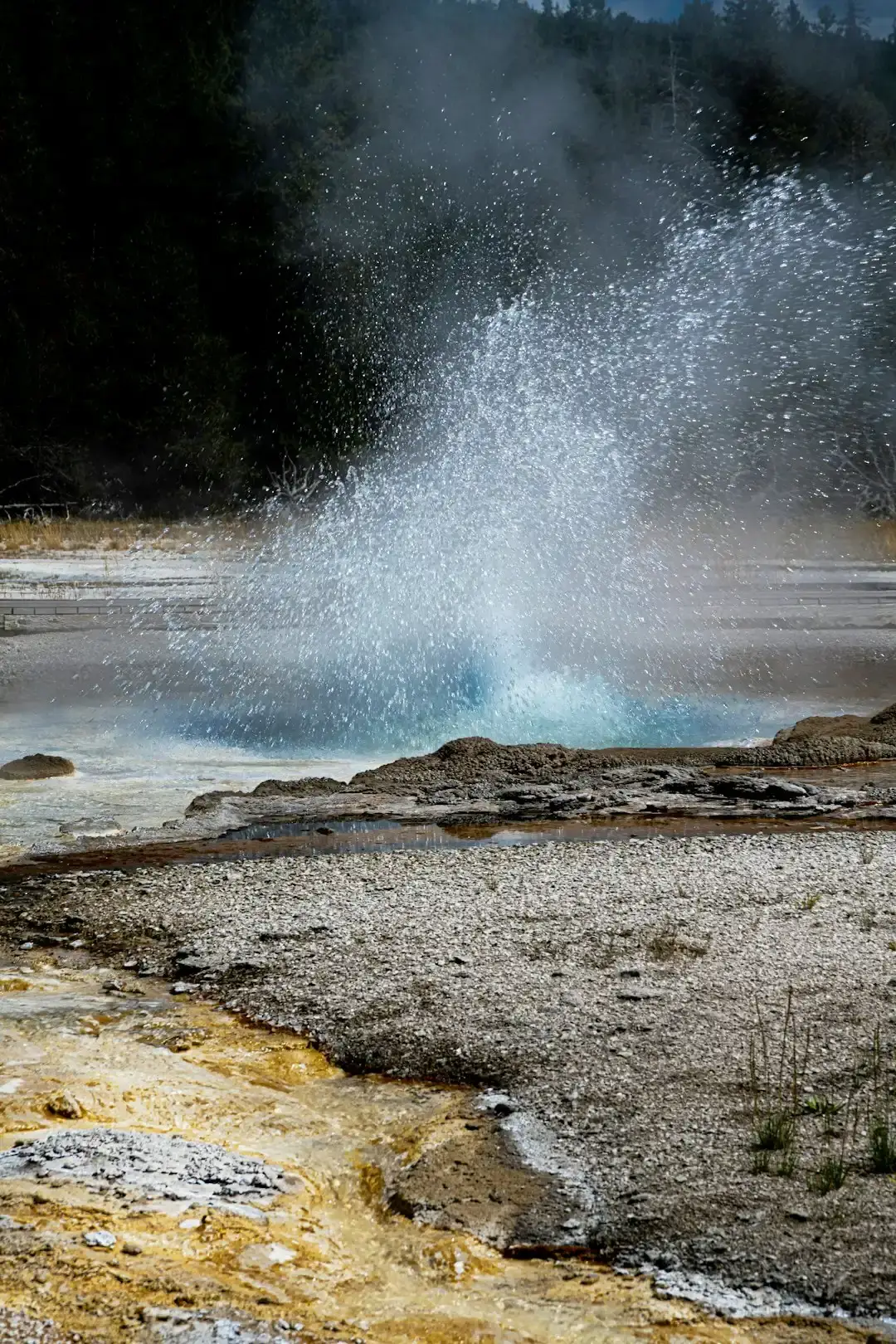
Let’s be real, Yellowstone isn’t just a park. It’s sitting on top of a supervolcano. There are only about 1,000 active geysers on Earth, and about half of them are in Yellowstone. That concentration alone makes it one of the strangest places on the planet.
According to Scott Bryan’s book The Geysers of Yellowstone, there are at least 700 geysers in Yellowstone, with at least 500 that actively erupt. Walk through any of the park’s geyser basins and you’ll see steam venting from the ground, water bubbling up through cracks, and pools so vividly colored they look digitally enhanced. The smell of sulfur hangs in the air like a reminder that the earth beneath you is very much alive.
The park sits atop a massive volcanic hotspot, creating conditions that allow heat and pressure to build underground. Honestly, it’s a little unnerving when you think about it. Old Faithful erupts with clockwork regularity, but dozens of other geysers across the park are far less predictable, shooting boiling water skyward whenever the underground plumbing decides it’s time.
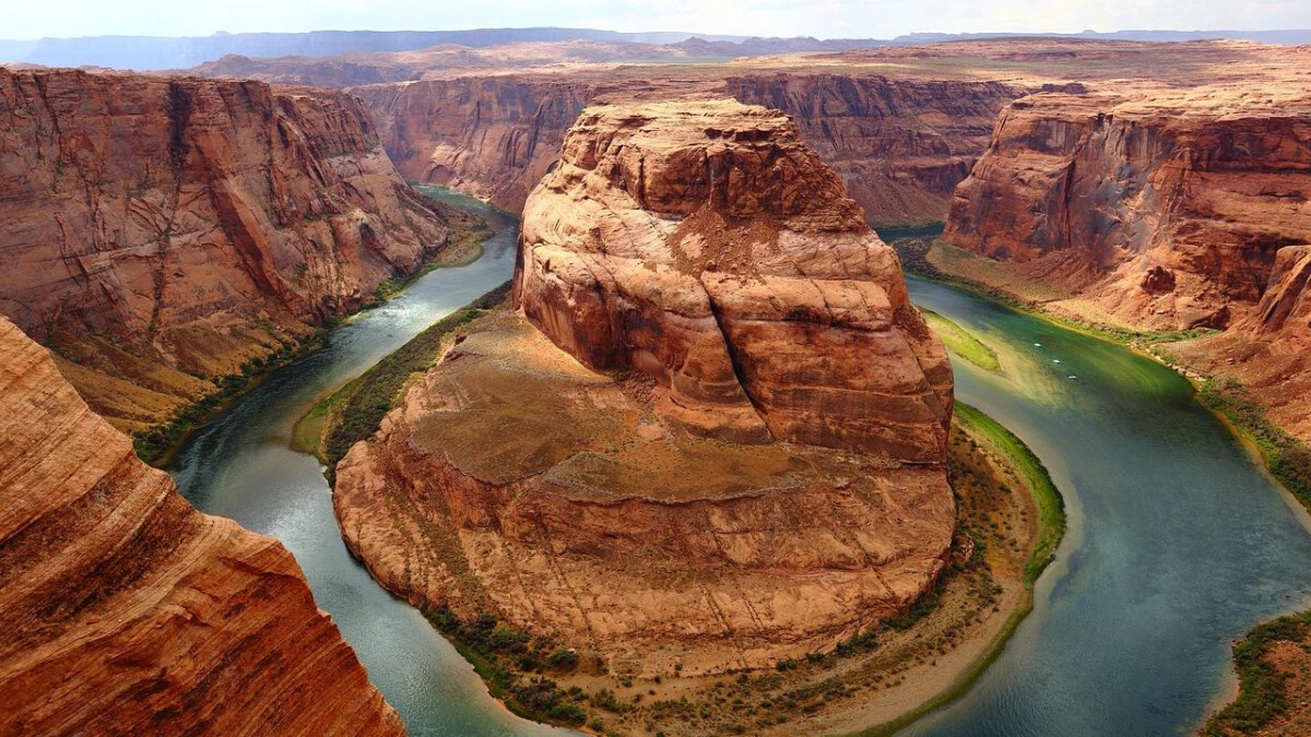
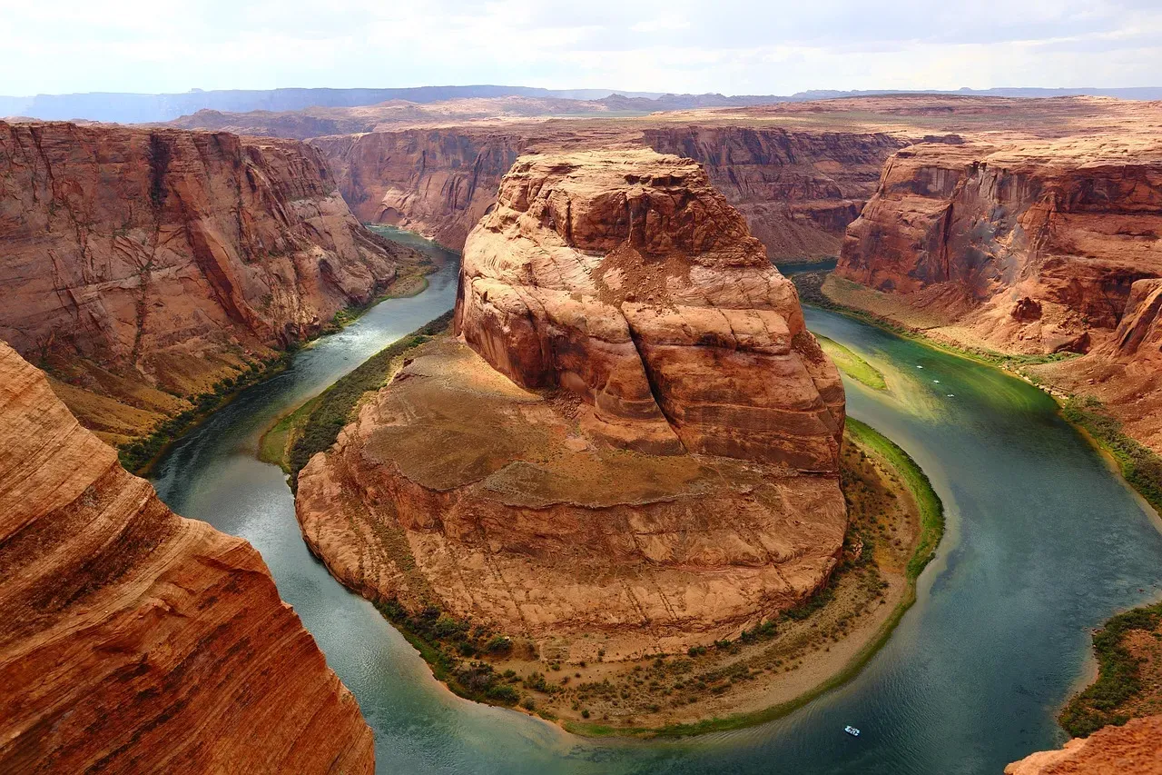
Horseshoe Bend: The River That Defied Gravity
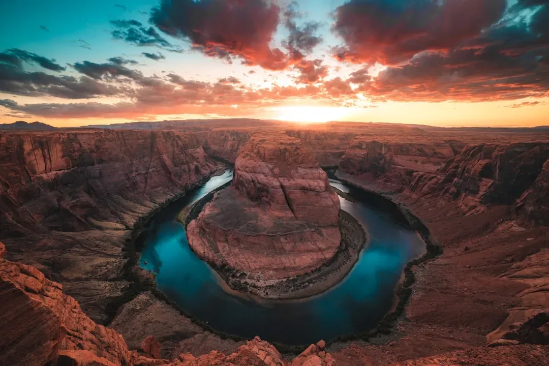
Horseshoe Bend attracts more than 2 million visitors a year, which is shocking considering how remote it feels. The overlook sits roughly a thousand feet above the Colorado River, which wraps around a massive sandstone tower in a near-perfect horseshoe shape. It’s one of those sights that photographs can’t quite capture.
Six million years ago, the region around Horseshoe Bend was much closer to sea level. Between six and five million years ago, the region began to be uplifted, trapping the Colorado River in its bed and causing the river to rapidly cut downwards to produce what we see today. The bend itself is a geological accident, a moment frozen in stone where the river couldn’t escape its own path.
What’s crazy is the surge in popularity. In 2017, the first year visitation was officially tracked, the trail drew more than 1.3 million people, close to 4,000 a day. That kind of foot traffic has forced officials to add safety features and expand infrastructure just to keep up. The view is undeniably spectacular, but it’s also a reminder of how fragile these places can be under the weight of human attention.
Crater Lake: America’s Deepest Secret
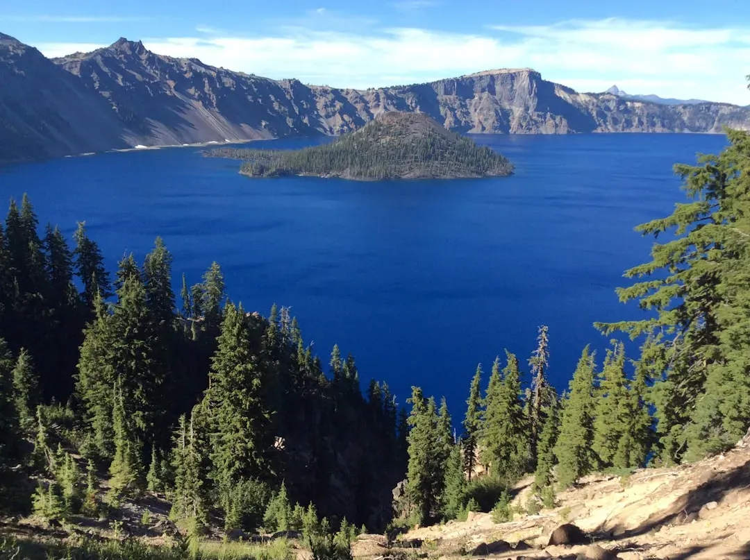
Crater Lake’s maximum depth has been measured at 1,949 feet, making it the deepest lake in the United States. It sits inside a collapsed volcanic crater, filled entirely by rain and snowmelt over thousands of years. The lake has no inlets or tributaries, which makes the waters some of the purest in the world because there’s nothing flowing in to carry pollutants or sediment.
The blue color is almost unsettling in its intensity. Clarity readings from a Secchi disk have consistently been measured at 120 feet, meaning you could see a white plate sunk that deep. The maximum individual clarity reading was 41.5 meters in June 1997, a record that speaks to the lake’s extraordinary purity.
Here’s the thing though: In 2025, scientists recorded a clarity of 78 feet, which may be an indication of issues with the lake’s physics, chemistry, and ecology. Changes like that don’t happen without a reason. The lake is so isolated and so carefully balanced that even minor shifts can signal something larger at play. It’s beautiful, yes, but also delicate in ways most visitors never realize.
Antelope Canyon: Beauty Shaped by Danger
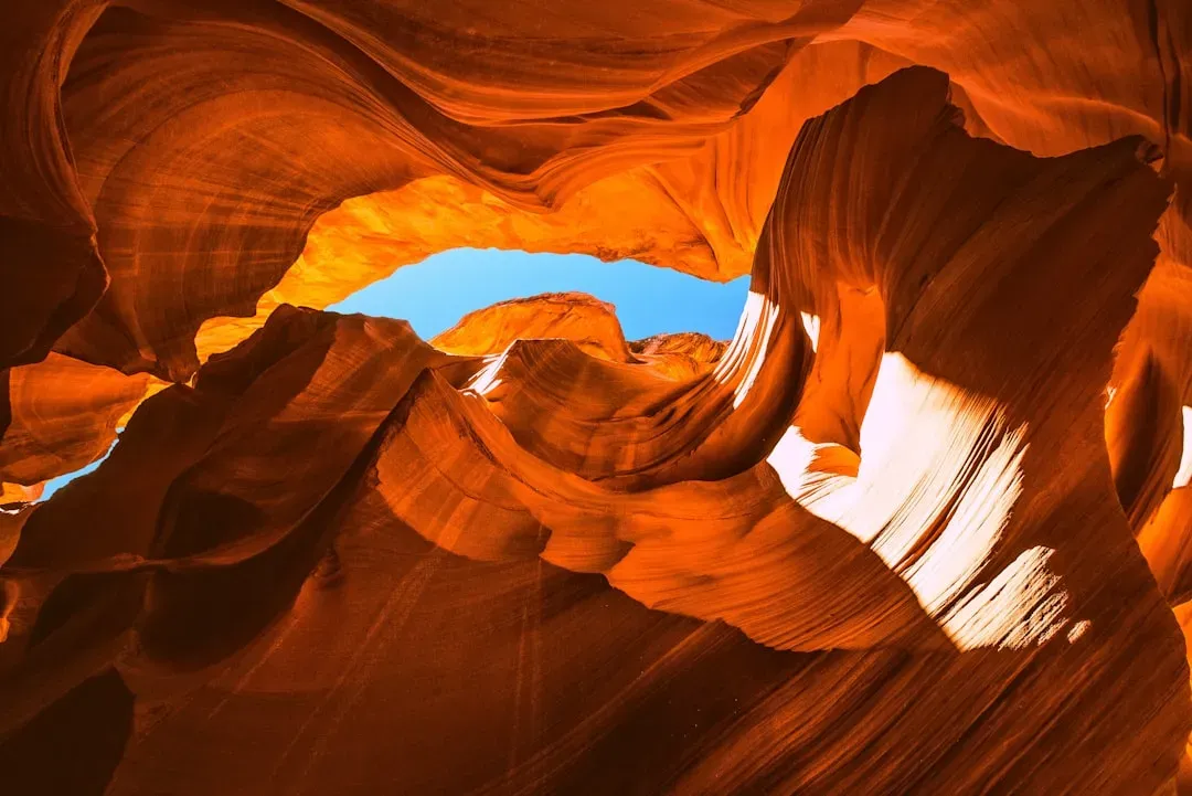
Antelope Canyon was formed by the erosion of Navajo Sandstone due to flash flooding. Rainwater, especially during monsoon season, runs into the basin above the slot canyon sections, picking up speed and sand as it rushes into the narrow passageways. The result is a series of smooth, flowing walls that look more like sculpted art than natural rock.
The light beams that filter down through cracks in the ceiling have made this one of the most photographed places in the American Southwest. Yet the same forces that created this beauty remain a serious threat. On August 12, 1997, eleven tourists were killed in Lower Antelope Canyon by a flash flood. Very little rain fell at the site that day, but an earlier thunderstorm dumped a large amount of water into the canyon basin 7 miles upstream.
Flash floods play a central role in the creation of slot canyons, carving deep, narrow gorges into the landscape and shaping the canyon walls over thousands of years. It’s a reminder that the most stunning places are often the most dangerous. Visiting Antelope Canyon now requires a guided tour, and operators monitor weather conditions constantly. The canyon is breathtaking, but it demands respect.
Mount Rainier: A Giant Wrapped in Ice
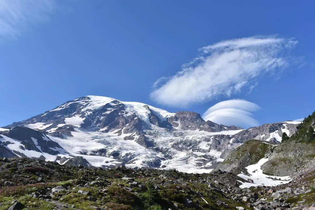
Mount Rainier might not be the tallest peak in the contiguous United States, but it’s one of the most heavily glaciated. The mountain holds 25 major glaciers, covering more surface area than any other peak in the lower 48 states. That’s a staggering amount of ice clinging to a single volcano.
What makes Rainier so imposing is the way it dominates the landscape. On clear days, you can see it from Seattle, looming over the horizon like a sentinel. The glaciers that wrap around its slopes are in constant motion, grinding down rock and reshaping the mountain inch by inch. Climate change is affecting them, causing some to retreat, but the sheer volume of ice still present is hard to comprehend until you’re standing at the base looking up.
Honestly, it’s both majestic and a little intimidating. The mountain is still an active volcano, which means all that ice sits on top of something that could theoretically erupt again. For now, though, it remains one of the most dramatic examples of glaciation in the country, a frozen giant that refuses to be ignored.