
Google Earth offers a stunning view of nearly every corner of the planet, letting anyone zoom in on streets, buildings, and landscapes from above. Yet certain spots in the United States remain stubbornly obscured, showing pixelated patches, outdated images, or low-resolution blurs instead of clear details. These areas often tie back to national security concerns, where governments request limited visibility to protect sensitive operations.
While most of the country appears in sharp focus, these four locations stand out for their deliberate vagueness on the satellite imagery. Exploring them reveals how mapping technology balances public access with restricted information. Recent checks confirm these patterns persist into 2026.[1][2]
1. Groom Lake (Area 51), Nevada
The remote Groom Lake facility, better known as Area 51, sits in the Nevada desert and has long fueled speculation about secret aircraft testing. Satellite views here stick to older, lower-resolution images that hide recent changes and runway details. The U.S. Air Force maintains strict control over the site, ensuring no high-definition glimpses slip through.[2]
Even as imagery has improved slightly over the years, the perimeter stays classified, with surrounding roads and access points often simplified or outdated. This approach keeps operational secrecy intact amid public curiosity. As of 2026, zooming in still yields a hazy picture rather than crisp reality.[3]
2. Dugway Proving Ground, Utah
Nestled in Tooele County, Dugway Proving Ground serves as a key U.S. Army site for testing chemical and biological defense systems. Parts of the base, including the Michael Army Airfield building, appear completely blacked out or heavily pixelated on Google Earth. Security needs drive this censorship to shield testing areas from prying eyes.[4]
The vast desert expanse hides runways and structures under blurred rectangles, making it hard to discern layouts or equipment. Historical imagery shows more detail in some spots, but current views prioritize obscurity. This setup reflects ongoing sensitive work at the facility through 2026.
Local reports note the base’s role in classified experiments, reinforcing the need for limited satellite access. Visitors nearby might catch glimpses, but from space, it remains a shadow.
3. HAARP Facility, Gakona, Alaska
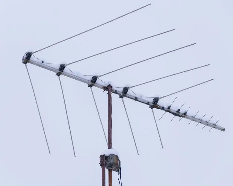
The High-frequency Active Auroral Research Program (HAARP) in Gakona features a sprawling array of antennas for ionospheric studies. While once more heavily obscured, recent imagery shows some clearing, yet details around the core setup stay low-res or patchy. The site’s shift to University of Alaska operation hasn’t fully lifted all visual restrictions.[2]
Conspiracy theories once swirled about weather control here, but official purposes focus on radio science. Google Earth renders the antenna field in muted tones, avoiding sharp overhead shots. Into 2026, open houses occur, yet satellite views lag behind ground-level access.[5]
4. Westchester County Blurred Zones, New York
In Westchester County, New York, Google Maps and Earth blur out specific public spots like amusement parks, beaches, and parking lots. County officials requested this to deter potential terrorism targets after 9/11 concerns. These pixelated areas stand out amid otherwise clear suburban views.[1]
The blurring affects satellite imagery directly, creating mosaic-like patches over vulnerable sites. No recent updates indicate removal, keeping these zones indistinct as of 2026. This local request highlights how even non-military areas can vanish from digital maps for safety.
Drive around virtually, and street view might align, but from above, the intent to obscure remains evident.
Why These Spots Stay Hidden
Across these sites, patterns emerge around military testing, research, and security hotspots. Google complies with U.S. government requests to blur or use legacy images, balancing transparency with protection. Evidence from mapping lists and recent articles confirms no major changes by 2026.[1]
Technology evolves, yet some secrets demand shadows. Next time you explore Google Earth, those dark patches remind us of boundaries in our connected world.