
Pacific Coast Highway, California
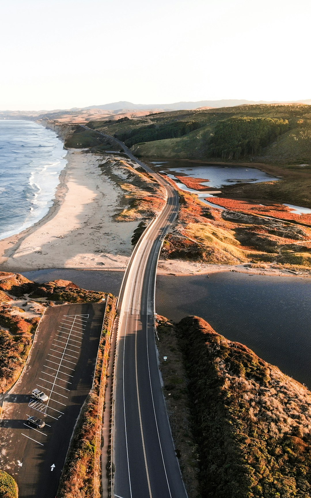
The Pacific Coast Highway, often called PCH or California State Route 1, is a legendary drive hugging the western edge of the United States. Spanning more than 650 miles between San Francisco and San Diego, this route offers some of the most dramatic ocean vistas in the world. Travelers wind through seaside towns like Carmel-by-the-Sea and Santa Barbara, experiencing both wild cliffside views and inviting sandy beaches. According to AAA, the PCH is among the top five most-traveled scenic highways in the U.S., with millions of visitors each year. The spring and fall are the best times for this journey, with milder weather and fewer crowds, making it easier to spot migrating whales or blooming wildflowers along the route. The Big Sur stretch, with its jagged cliffs and iconic Bixby Bridge, is a highlight that often leaves visitors speechless. Restaurants serving fresh seafood and cozy inns dot the journey, offering plenty of reasons to stop and savor the scenery. Driving the Pacific Coast Highway feels like a cinematic adventure, blending natural beauty with a sense of freedom and endless possibility.
Route 66, The Mother Road
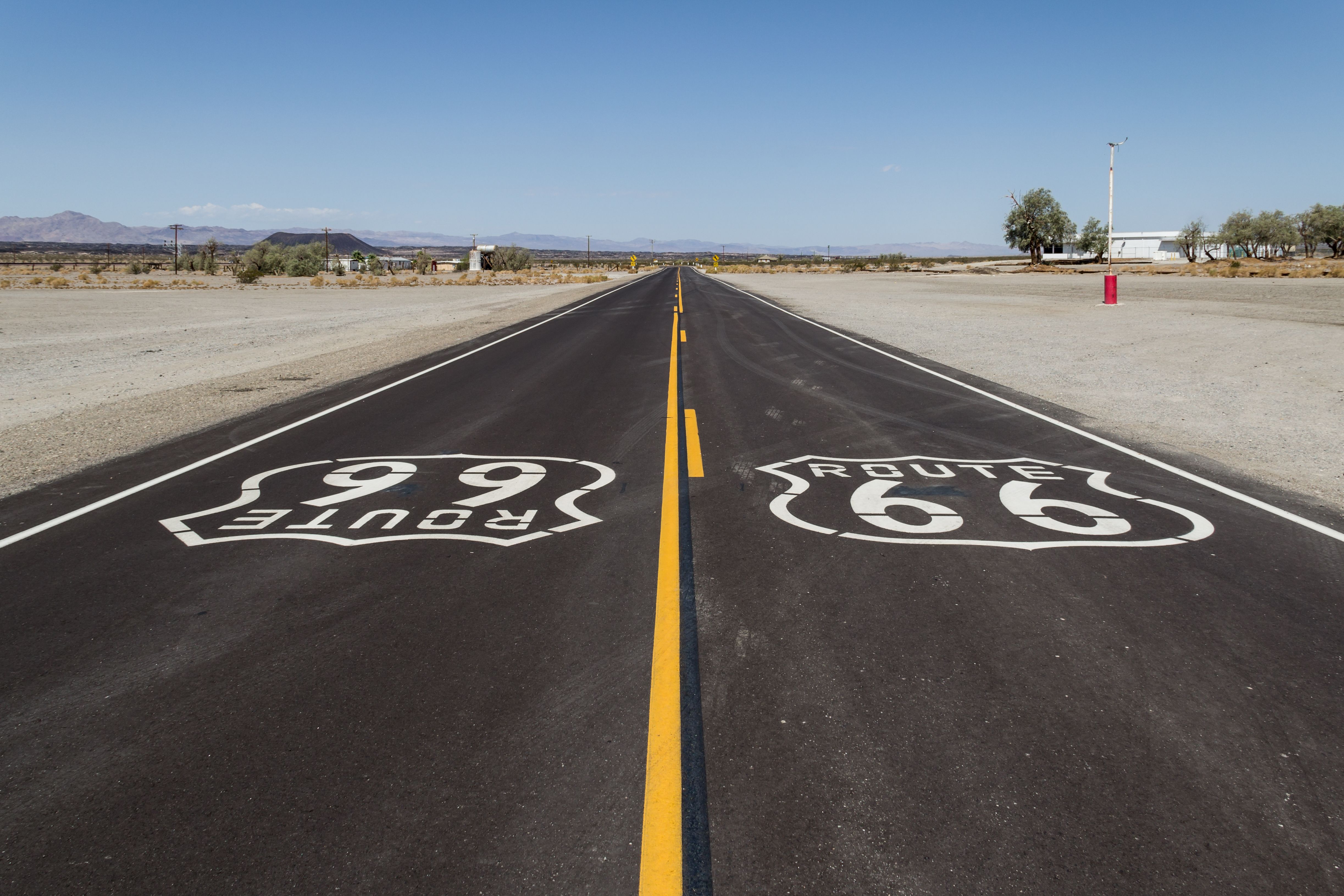
Route 66, known as “The Mother Road,” is the ultimate symbol of America’s love affair with the open road. Stretching 2,448 miles from Chicago to Santa Monica, it was established in 1926 and quickly became a pathway to prosperity for countless Americans. Today, travelers retracing this route discover classic diners, neon-lit motels, and quirky roadside attractions that keep the spirit of mid-century Americana alive. According to the National Park Service, Route 66 has seen a recent uptick in travelers, with a 15% increase in road trip bookings after the pandemic began. Stops like the Cadillac Ranch in Texas and the Blue Whale of Catoosa in Oklahoma provide Instagram-worthy moments and a dash of nostalgia. Many states have also invested in preserving their portions of the highway, adding historical markers and restoring vintage signage. The route is known for its friendly locals and a sense of camaraderie among fellow travelers. Driving Route 66 is less about reaching the end and more about savoring the journey and its colorful history.
The Blue Ridge Parkway, Virginia and North Carolina
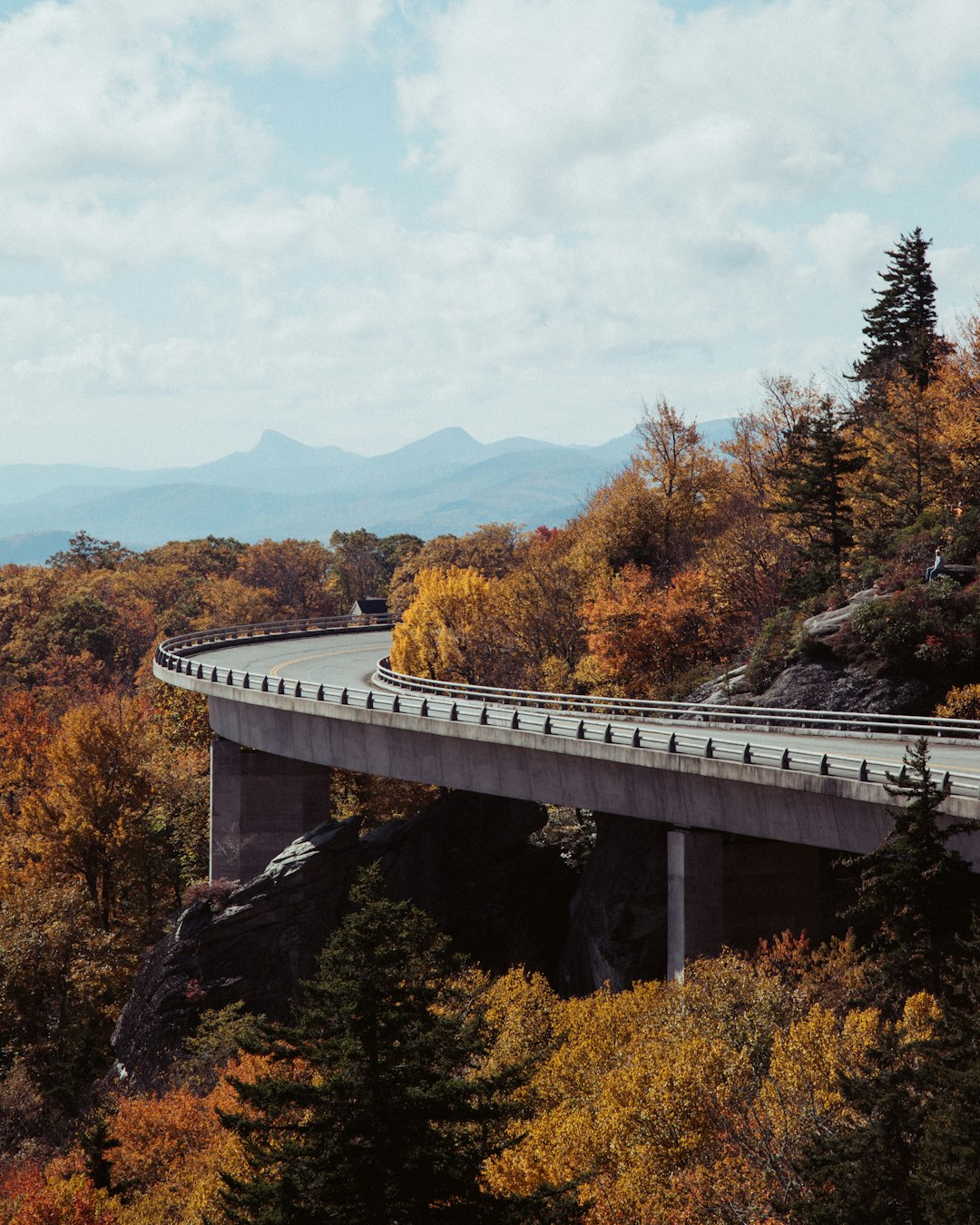
Often called “America’s Favorite Drive,” the Blue Ridge Parkway connects Shenandoah National Park in Virginia to the Great Smoky Mountains National Park in North Carolina. This 469-mile stretch is celebrated for its rolling mountains, lush valleys, and especially for its fiery autumn foliage. According to the National Park Service, over 15 million people visit the Blue Ridge Parkway annually, making it the most visited unit of the National Park System. Spring brings carpets of wildflowers, while fall is famous for its intense reds, oranges, and golds. The road is dotted with scenic overlooks, hiking trailheads, and places to picnic or camp, making it perfect for both short stops and long explorations. Visitors often encounter local musicians at roadside pull-offs, providing a soundtrack of Appalachian folk music. The parkway is also a haven for birdwatchers and photographers, thanks to its diverse wildlife and panoramic views. Driving here is a peaceful immersion into natural beauty and local culture.
The Florida Keys Scenic Highway

The Florida Keys Scenic Highway, officially U.S. Route 1, is a 113-mile route that threads its way from Key Largo to Key West across a chain of islands. The journey is famous for its turquoise waters, sun-drenched bridges, and the iconic Seven Mile Bridge, which seems to float above the ocean. According to Visit Florida, the Keys receive over 3 million visitors every year, with many coming specifically for this stunning drive. Along the way, drivers can stop for snorkeling, fishing, or sampling fresh seafood in colorful seaside shacks. Key West, at the journey’s end, offers historic sites like the Ernest Hemingway Home and vibrant nightlife on Duval Street. The best time to experience this road trip is in winter, when the weather is warm and hurricane risks are low. Roadside parks and marinas invite travelers to linger, while crystal-clear waters teem with tropical fish and playful dolphins. The Florida Keys Scenic Highway is both a visual feast and a playground for adventure-seekers.
The Alaska Highway
The Alaska Highway, or Alcan Highway, is a legendary route that stretches 1,390 miles from Dawson Creek, British Columbia, to Delta Junction, Alaska. Built in 1942 as a military supply route during World War II, it now serves as a gateway to the wild heart of North America. According to the Alaska Department of Transportation, tens of thousands of vehicles travel this rugged highway each summer, despite its remote stretches and unpredictable weather. Travelers encounter vast forests, snow-capped peaks, and an abundance of wildlife, including bears, moose, and eagles. Services can be few and far between, so planning is essential—many gas stations and lodges close in winter. The Alaska Highway is prized by RVers and adventure travelers for its sense of isolation and vast, untouched scenery. Historic roadhouses along the route offer a glimpse into the pioneering spirit that built the highway. Each mile on the Alaska Highway feels like a step farther from civilization and deeper into the wild.
The Cabot Trail, Nova Scotia
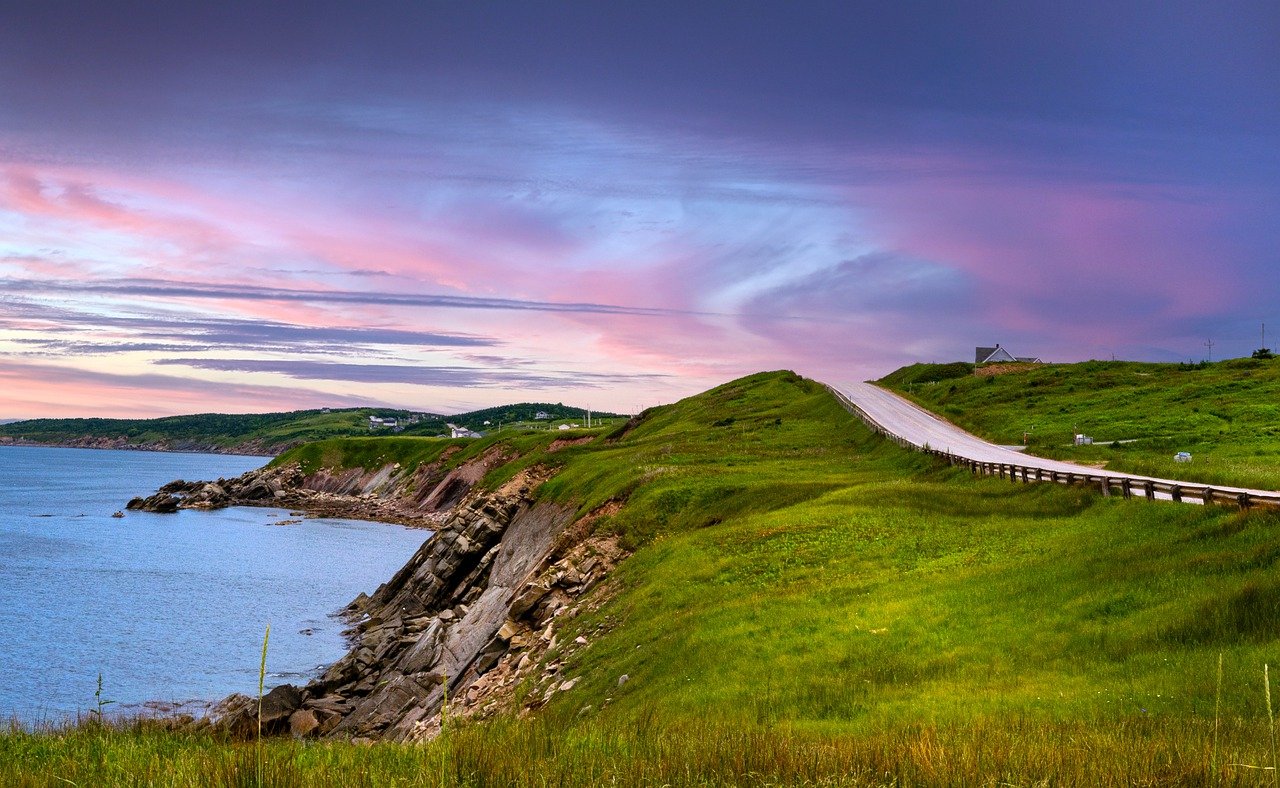
The Cabot Trail is a 185-mile loop that winds through the Cape Breton Highlands in Nova Scotia, offering some of the most dramatic coastal scenery in Canada. According to the Nova Scotia Tourism Agency, the trail attracts more than 300,000 visitors a year, many drawn by its sweeping ocean vistas and forested mountains. Whale-watching, hiking, and exploring quaint fishing villages are just a few of the activities along the way. The trail is especially famous for its autumn display, when forests explode with red, orange, and yellow. The area’s Celtic heritage is on full display, with lively music festivals and artisan shops dotting the route. Small inns and cozy seafood restaurants provide warm welcomes and fresh lobster. The best time to visit is September to October, when the weather is crisp but comfortable and crowds are thinner. Driving the Cabot Trail is a blend of wild adventure and cultural immersion.
U.S. Route 50: The Loneliest Road in America
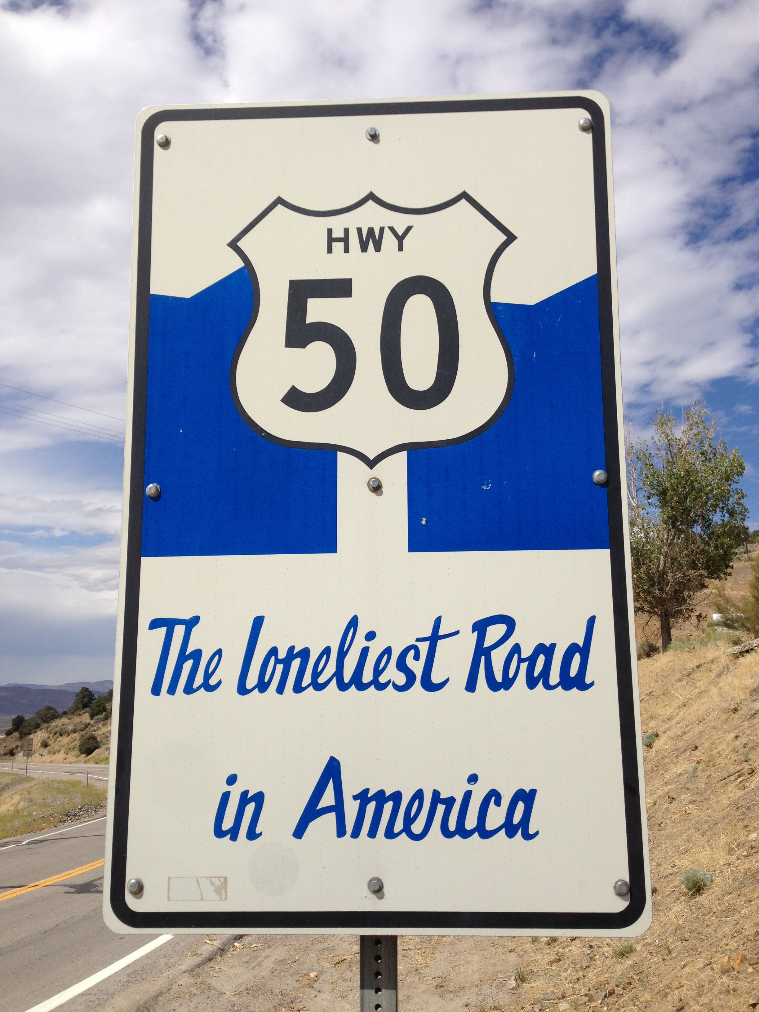
U.S. Route 50, often dubbed “The Loneliest Road in America,” crosses the vast deserts and mountain ranges of Nevada. Stretching 287 miles from Ely to Fernley, this route is known for its stark, empty landscapes and tiny towns that feel lost to time. According to the Nevada Commission on Tourism, Route 50 is gaining popularity among travelers seeking solitude and a break from the modern world. Along the way, drivers encounter ghost towns, ancient petroglyphs, and roadside oddities like the Shoe Tree. The road’s isolation is its biggest charm—there are stretches where you might not see another car for miles. Spring and fall offer the most comfortable travel conditions, as summer can be dangerously hot and winter brings snow and icy roads. Despite its reputation, services and attractions are scattered along the route for those who plan ahead. For many, driving Route 50 is a meditative experience, offering a rare sense of quiet and reflection.
The Historic Columbia River Highway, Oregon
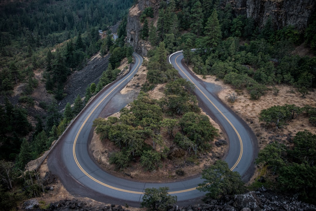
The Historic Columbia River Highway runs 75 miles through the Columbia River Gorge, east of Portland, Oregon. Built in the early 20th century as America’s first scenic highway, it’s famous for its waterfalls, including the 611-foot Multnomah Falls, and dramatic basalt cliffs. The Oregon Department of Transportation reports that over 2 million visitors travel this highway each year, with spring being the most popular season due to the roaring waterfalls. The drive includes numerous pullouts for hiking, photography, and picnicking. Historic tunnels and stone guardrails evoke the craftsmanship of a bygone era. Towns like Hood River offer charming downtowns with local breweries and farm-to-table restaurants. The route is also a favorite among cyclists and motorcyclists, thanks to its winding curves and breathtaking views. Each turn on the Historic Columbia River Highway reveals a new natural wonder or historic site.
The Texas Hill Country

The Texas Hill Country is a sprawling region of rolling hills, limestone cliffs, and vibrant wildflowers, spanning central Texas from Austin to San Antonio. According to the Texas Hill Country Tourism Board, millions of visitors flock here every spring to witness bluebonnets in full bloom. The region’s winding roads offer stunning views and pass through historic towns such as Fredericksburg, known for its German heritage and wineries. Small towns like Wimberley and Luckenbach charm visitors with quirky shops, live music, and friendly locals. The area is also home to natural swimming holes like Hamilton Pool, and hiking spots such as Enchanted Rock. Spring and early summer are ideal for a road trip, with wildflowers blanketing the countryside and pleasant temperatures. Many travelers plan their drives around festivals celebrating music, food, and local culture. The Texas Hill Country delivers a blend of natural beauty, relaxation, and down-home hospitality.
Icefields Parkway, Alberta
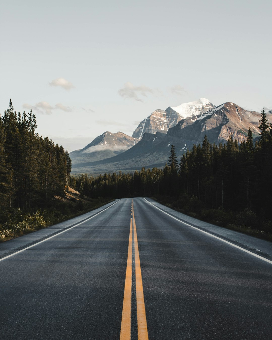
The Icefields Parkway in Alberta is considered one of the most beautiful drives in the world, running 144 miles between Jasper and Lake Louise in the Canadian Rockies. According to Parks Canada, more than 1.2 million vehicles travel the parkway each year, drawn by its glaciers, turquoise lakes, and jagged peaks. The route passes by more than 100 ancient glaciers and iconic sites like the Athabasca Glacier and Peyto Lake. Wildlife sightings are common, with black bears, elk, and bighorn sheep often spotted near the road. Pullouts and interpretive signs encourage travelers to stop and learn about the area’s unique geology and history. The best time to drive the Icefields Parkway is from June to September, when the road is clear of snow and hiking trails are open. Visitors can also take guided glacier walks or boat tours on the lakes. The Icefields Parkway is a photographer’s dream, offering new jaw-dropping vistas around every corner.
Going-to-the-Sun Road, Montana
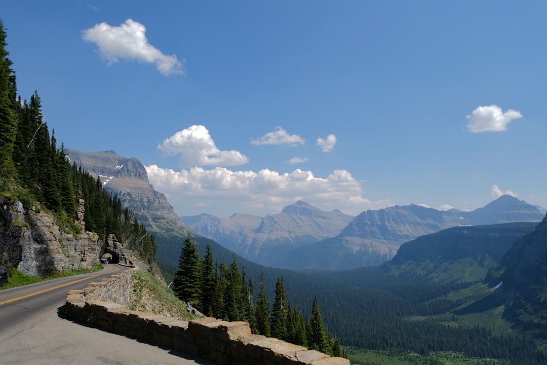
Going-to-the-Sun Road is a 50-mile engineering marvel that slices through the heart of Glacier National Park in Montana. The drive, open only from late June to mid-September due to snow, climbs to 6,646 feet at Logan Pass, offering sweeping views of glacier-carved valleys and snow-dusted mountains. According to the National Park Service, the route draws about 3 million visitors each year, with most coming during the short summer window. Along the way, travelers can hike to hidden waterfalls, spot mountain goats, and picnic beside crystal-clear lakes. The road itself is narrow and winding, adding a sense of adventure and thrill to the journey. The park encourages visitors to use shuttle buses to reduce congestion and protect the fragile alpine environment. Wildflower meadows and fields of huckleberries make it a feast for the senses. Going-to-the-Sun Road is a must-drive for anyone seeking awe-inspiring mountain scenery and a touch of adrenaline.
Overseas Highway, Florida

The Overseas Highway, a 113-mile stretch of U.S. Route 1, connects mainland Florida with Key West via a series of 42 bridges. According to the Florida Department of Transportation, over 1 million vehicles cross the famous Seven Mile Bridge each year, making it one of the most photographed stretches of road in the country. The journey is lined with palm trees, turquoise waters, and opportunities to stop at islands for snorkeling, fishing, or sampling Key Lime pie. State parks and marine sanctuaries along the route make it easy for travelers to explore coral reefs and mangrove forests. Winter and early spring are the best times to avoid hurricane season and enjoy pleasant weather. The highway’s history is as fascinating as its scenery, with sections originally built in the early 1900s as part of Henry Flagler’s overseas railroad. Key West greets travelers with its laid-back charm, pastel houses, and vibrant nightlife. The Overseas Highway is a tropical escape that feels worlds away from the mainland.
Lake Superior Circle Tour
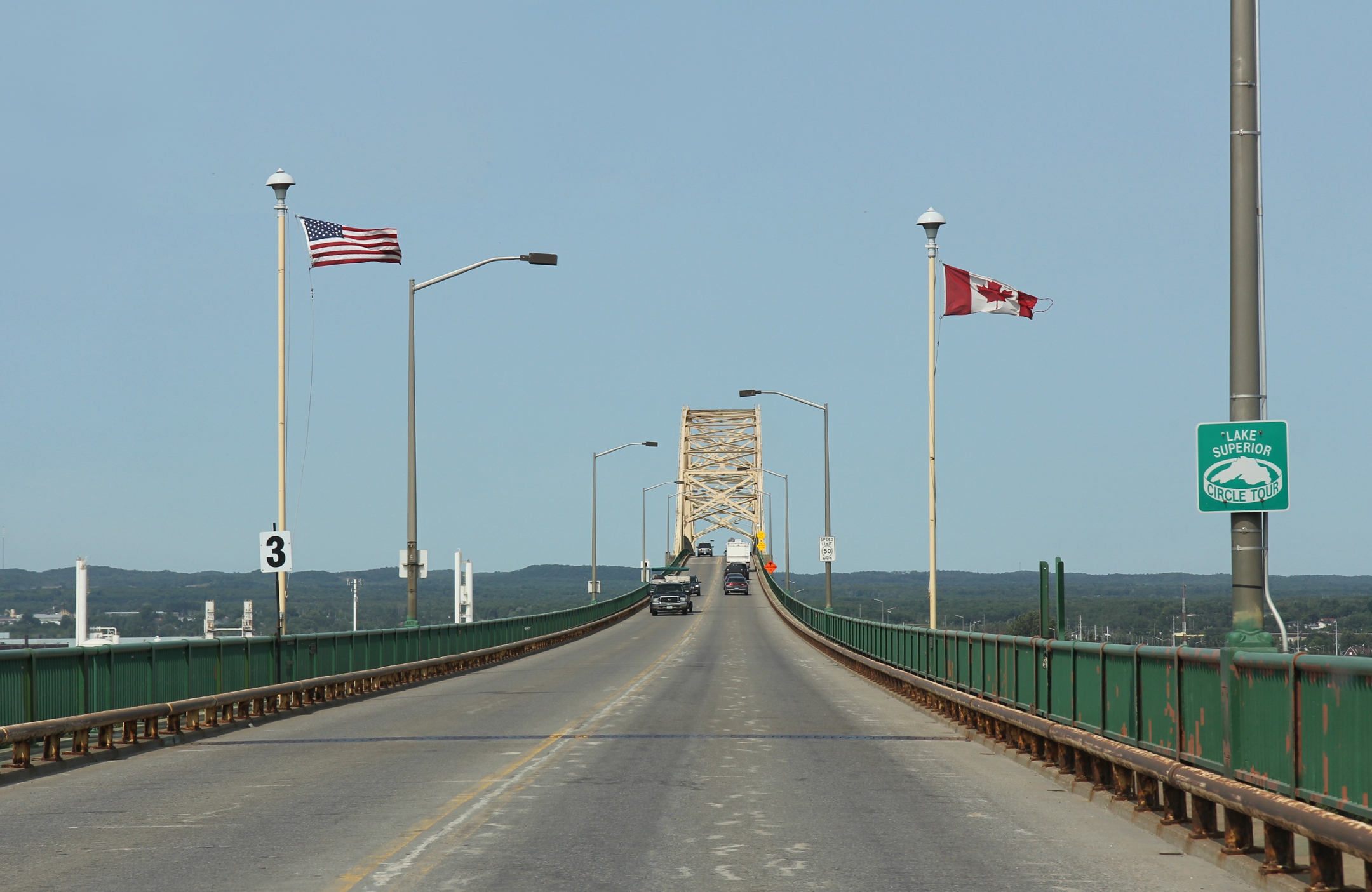
The Lake Superior Circle Tour is a 1,300-mile loop that encircles the largest of the Great Lakes, spanning both the U.S. and Canadian borders. According to the Lake Superior Circle Tour Association, over half a million travelers complete at least part of this route each year. The tour passes through pristine forests, rocky shorelines, and charming lakeside towns in Minnesota, Wisconsin, Michigan, and Ontario. Popular stops include Pictured Rocks National Lakeshore, Sleeping Giant Provincial Park, and the historic city of Thunder Bay. The best time to go is from late spring to early fall, when the weather is mild and the lake’s waters are at their calmest. Travelers can enjoy hiking, kayaking, and sampling local delicacies like smoked fish and wild blueberries. Lighthouses, waterfalls, and beaches offer endless opportunities for exploration. The Lake Superior Circle Tour is a grand adventure that celebrates the wild beauty of the North.
Sea to Sky Highway, British Columbia
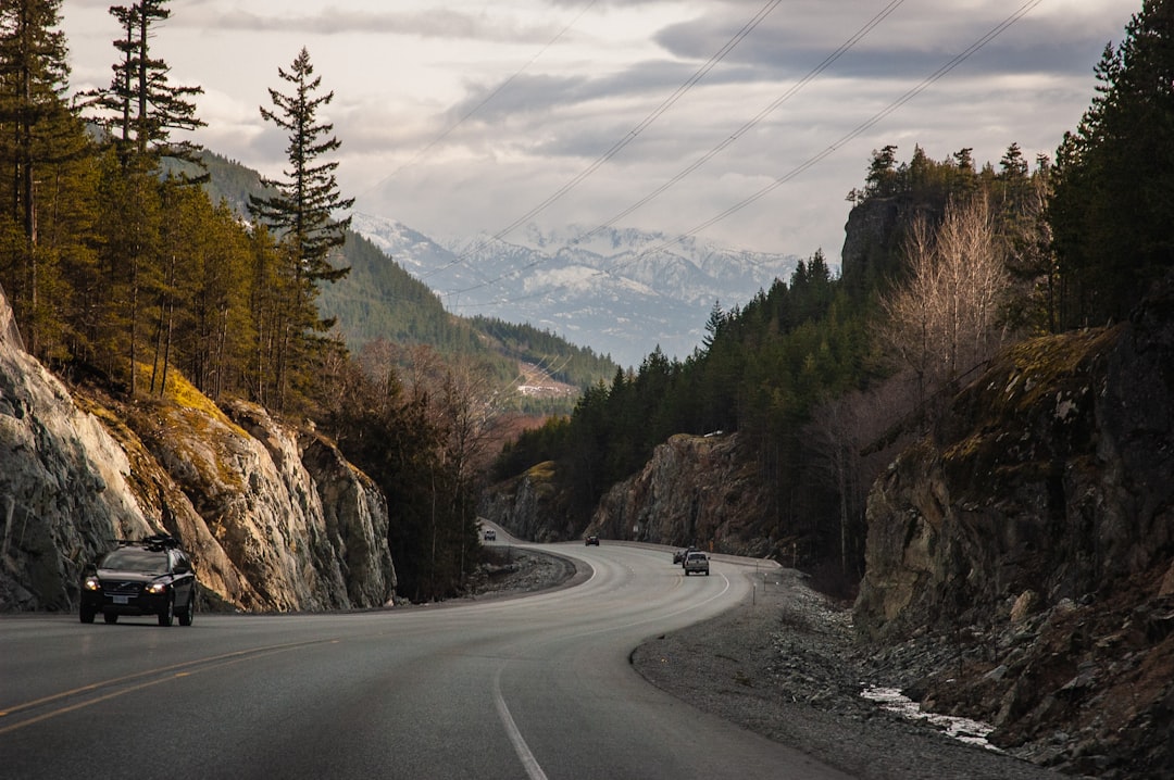
The Sea to Sky Highway, or Highway 99, runs 75 miles from Vancouver to Whistler, British Columbia, and is celebrated for its jaw-dropping mountain and ocean views. According to Destination BC, the route sees around 1.5 million vehicles annually, with traffic peaking during ski season and summer holidays. The drive hugs the edge of Howe Sound before climbing into the Coast Mountains, with frequent pullouts for waterfalls, hiking trails, and scenic lookouts. Stops like Shannon Falls, Squamish, and the Sea to Sky Gondola offer chances to stretch your legs and soak in the scenery. Whistler, at the end of the highway, is a world-renowned resort with year-round activities. The route is also rich in Indigenous history, with interpretive signs and cultural centers along the way. Spring and summer offer the best conditions for driving, with clear skies and wildflowers in bloom. The Sea to Sky Highway is an exhilarating introduction to Canada’s west coast wilderness.