
Atlantic Sea Surface Temperatures on the Rise
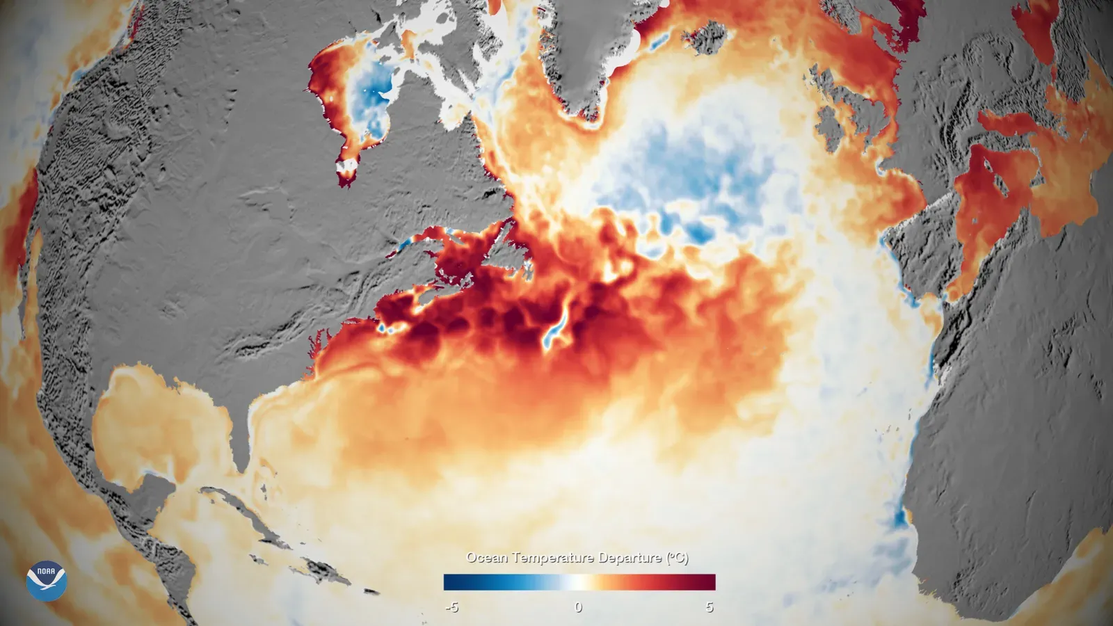
Sea surface temperatures across the Atlantic have climbed sharply since early 2026, with many areas now exceeding the critical threshold of 26.5 degrees Celsius needed for tropical storm development. This warming trend mirrors patterns seen in recent years, where oceans absorbed excess heat from greenhouse gases and natural variability. Buoys in the main development region report anomalies of 1 to 2 degrees above average, setting the stage for potential early activity. Gulf waters, in particular, show hotspots near Florida and Texas running 2 to 4 degrees hotter than last year at this time. Such conditions fuel convection and low pressure systems that can spin up quickly. Scientists note this buildup often precedes busier early seasons, even if overall forecasts temper expectations. Warmth persists despite cooler high-latitude pockets, keeping energy high near the tropics.
Historical data underscores the risk, as 2023’s record 20 named storms tied directly to similar ocean heat. The 2024 season followed with 18 tropical storms, many intensifying over warm Atlantic pools. Last year, 2025 brought above-average activity too, with clusters of hurricanes forming amid persistent warmth. Current maps reveal expansive orange and yellow zones across the basin, signaling abundant fuel. This isn’t just a blip; global SSTs hit new highs again this spring. Early June disturbances could tap this energy before shear builds later. Communities watch closely as these trends echo pre-storm setups from hyperactive years.
Early April Signals Point to June Threats

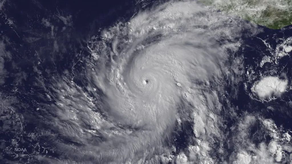
April 2026 observations show the Atlantic main development region warming faster than typical spring rates, with anomalies pushing toward El Niño-modulated patterns. Satellite imagery captures broad swaths above 27 degrees Celsius, ideal for genesis even outside peak months. Gulf buoys log 28 to 29 degrees in key zones, ripe for early spin-ups. Favorable upper-level winds add to the mix, reducing early shear over the western basin. This setup recalls 2023’s early former, when warmth sparked the season’s first systems by late May. Forecasters flag a higher odds for pre-June activity if trends hold. Low pressure troughs dipping from Canada could ignite the first waves.
Recent seasons amplify concerns, as 2024 saw an early storm brush the Gulf before official start. In 2025, rapid developments caught many off guard amid similar warmth. Current models hint at 20 to 30 percent chances for named storms by mid-June. Atmospheric moisture from lingering La Niña effects lingers, boosting rainfall potential. These signs demand vigilance, as early hits often strike unprepared areas. Gulf trackers note reduced trade winds aiding organization. June could deliver the first punches if convergence lines align just right.
Gulf of Mexico’s Rapid Heating Vulnerability

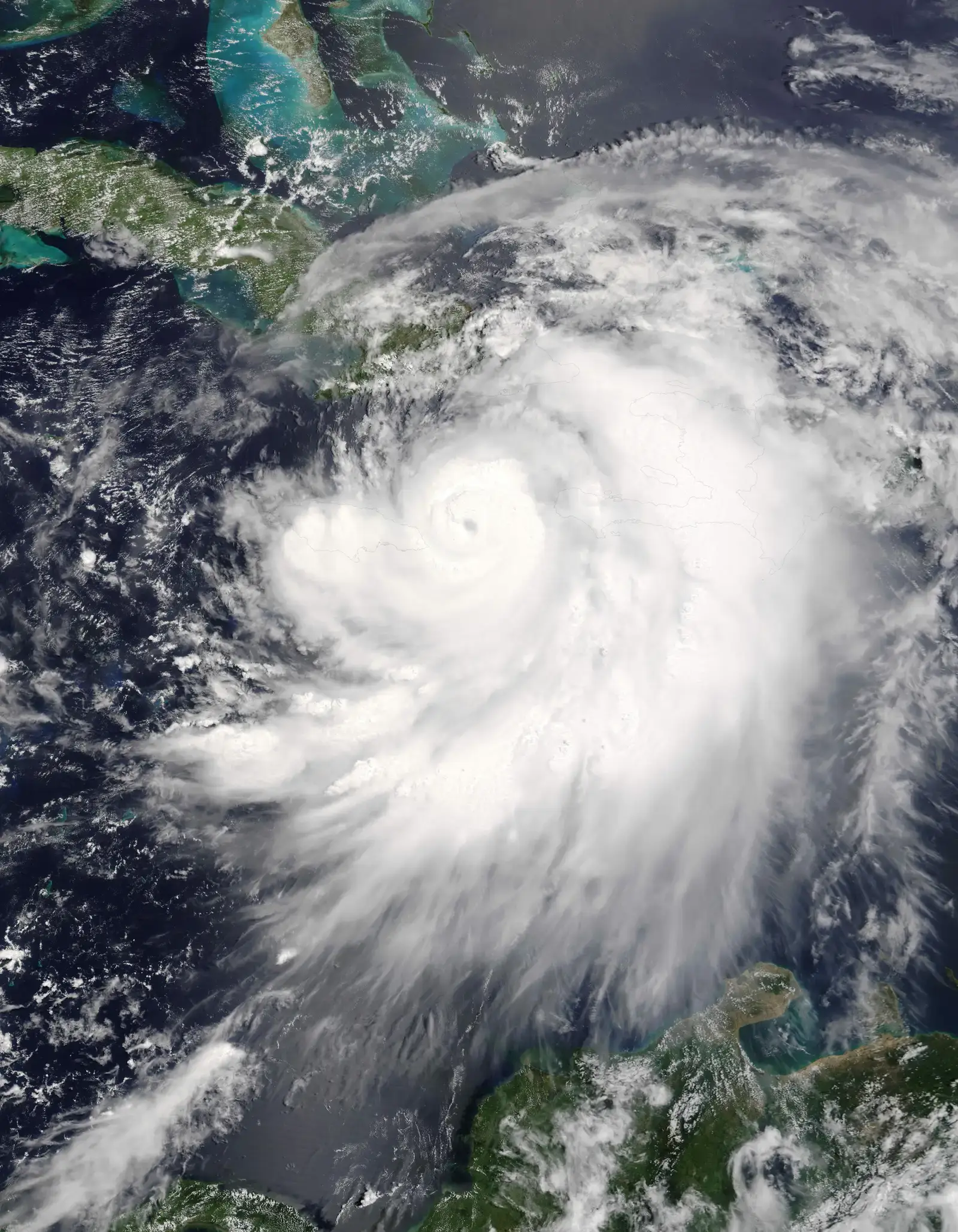
The Gulf heats up quicker than the open Atlantic due to its enclosed shape and shallow depths, trapping solar energy efficiently. Early 2026 data shows core waters at 28 degrees Celsius, well above the 26.5-degree formation line. This shallow basin amplifies rapid intensification, where storms jump 35 miles per hour in wind speed within 24 hours. Texas and Louisiana bays already simmer at near-record levels for April. Such conditions powered 2023’s quick-strengtheners like Idalia. Salinity drops from river outflows further destabilize the surface, promoting updrafts. Enclosed geography funnels storms toward coastlines relentlessly.
2024’s Beryl exemplified Gulf-fueled fury, exploding from tropical storm to Category 5 in under two days over these waters. 2025 storms similarly leveraged the heat, causing outsized surges. Current forecasts peg Gulf SSTs holding 1.5 degrees above average through June. Limited ventilation allows heat to build unchecked. This vulnerability extends seasons, with early June threats more likely now. Barrier islands feel the brunt first, eroding under sustained warmth-driven swells. Proactive monitoring remains essential as patterns repeat.
Increasing Frequency of Rapid Intensification
Rapid intensification events have surged in recent decades, tied to warmer oceans providing endless fuel. Defined as 35 mph wind gains in 24 hours, these jumps now occur nearly twice as often since 2000. Gulf hotspots lead, with 2023 logging multiple cases amid peak heat. 2024’s four major hurricanes all rapidly strengthened over warm bays. Last season, 2025 saw three such events, overwhelming forecasts. Early 2026 warmth suggests June could host the phenomenon again. Vertical wind shear drops in spring setups, allowing unchecked growth.
Communities face compressed warning times, often hours instead of days. Infrastructure strains under sudden Cat 4 impacts. Historical averages show one per season; recent years double that. Atlantic-wide SST rise extends this risk basin-wide. Gulf’s enclosed warmth magnifies it locally. Models now bake in higher probabilities for 2026 early events. Preparation must assume the worst-case acceleration every disturbance.
Lessons from 2023’s Record-Breaking Season
The 2023 Atlantic season shattered norms with 20 named storms, far exceeding the long-term average of 14. Warm SSTs drove relentless formation, peaking with seven hurricanes. Gulf landfalls like Idalia brought catastrophic surges to Florida’s Big Bend. Early warmth mirrored current trends, sparking systems by June’s end. Total activity index hit 175 percent of normal. Flooding claimed most lives, amplified by wetter storms. Recovery costs topped billions, straining budgets.
That year highlighted Gulf vulnerability, with rapid intensifiers dominating. 2023’s patterns inform 2026 watches closely. Early-season parallels grow evident now. Infrastructure upgrades followed, yet gaps persist. Wetter atmospheres from heat added 20 percent more rain. Communities rebuilt resiliently, but scars linger. Vigilance draws directly from those turbulent months.
2024 and 2025 Activity Trends
2024 delivered 18 named storms, 11 hurricanes, and five majors, keeping pressure on coasts. Gulf-focused threats like Beryl tested early preparations severely. Accumulated cyclone energy reached high marks despite mid-season lulls. Warmth persisted, fueling late surges too. 2025 ramped up with 15 named storms, seven hurricanes, three majors per some tallies. Clusters battered the basin, echoing 2023 vigor. Gulf endured multiple brushes, honing response tactics.
Both years saw above-average intensity, with rapid events commonplace. SST anomalies drove the busyness consistently. Early starts became norm, pressuring June timelines. 2026’s warming evokes those setups precisely. Landfall risks stayed elevated despite numbers. Infrastructure held better, thanks to lessons learned. Trends signal no letup for vulnerable shores.
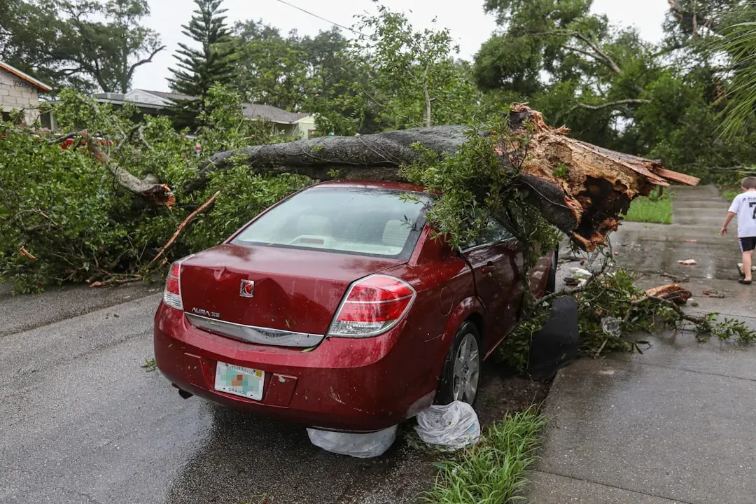
Gulf Coast’s Low-Lying Exposure

Texas, Louisiana, and Florida’s Gulf flanks sit mere feet above sea level, prime for storm surges. Subsidence sinks land further yearly, worsening risks. 2023’s Idalia pushed 10-foot walls inland swiftly. Ports and refineries cluster in harm’s way, vital to energy flows. Wetlands erode, stripping natural buffers. Early June storms hit before peak evacuations gear up. Surge models now predict 15-foot maxima under warm-fueled scenarios.
2024 and 2025 landfalls confirmed the peril, flooding highways and homes alike. Low elevations trap floodwaters days after passage. Infrastructure like levees strains under repeated hits. Communities invest in elevations, yet costs mount. Vulnerability indexes rank Gulf tops nationally. Early warnings save lives, but geography bites hard. Resilience builds slowly against relentless seas.
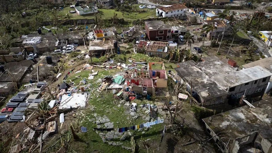
Impacts on Communities and Infrastructure
Warm-driven storms threaten power grids first, with outages lasting weeks in past hits. Gulf refineries halt, spiking fuel prices nationwide. Homes flood irreversibly, displacing thousands repeatedly. Schools and hospitals shutter, disrupting lives deeply. Economic tolls from 2023 alone neared 200 billion dollars. Early June catches tourists mid-season, swelling evacuee numbers. Mental health strains follow prolonged recoveries.
Infrastructure retrofits lag behind intensifying threats. Roads wash out, isolating rural spots. Water systems contaminate post-surge. 2024’s Beryl blacked out Houston for days. Communities drill evacuations yearly now. Federal aid helps, but prevention pays more. Forward planning turns vulnerability into strength over time.